


RockHoundR: Rockhounding Map
4.48.00 Reviews
App Specs
- Version
- 1.9.0
- Updated On
- License
- Free
- Downloads
- 10,000+
- Developer
- Ruby Glint Technologies
- Categories
- Maps & Navigation
- Platform
- Android
Screenshots
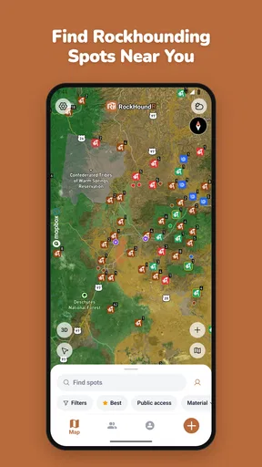
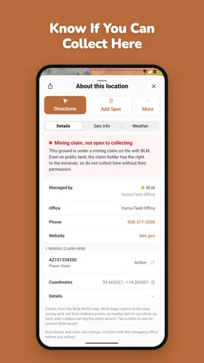
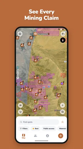
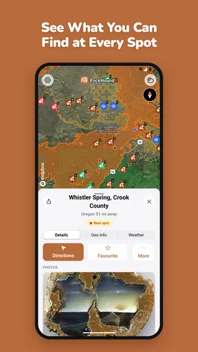
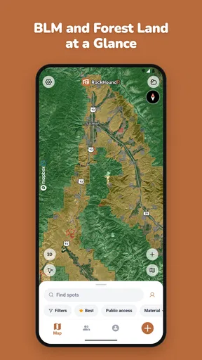
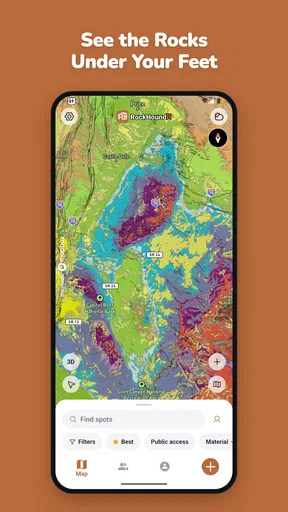
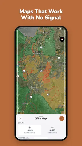
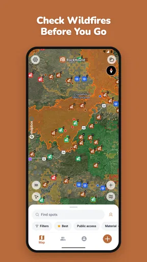
 Analysis by AppCompare
I approached RockHoundR: Rockhounding Map as a beginner rather than as someone who already knows every good collecting spot. That matters because a map built for rockhounding needs to do more than place pins on a screen: it should help a curious person understand where to start, what to look for, and how to turn a vague weekend idea into a sensible outing. My first impression is that this app has a clear purpose. It belongs in the Maps & Navigation category, but it is aimed at a much more focused activity than ordinary driving or walking apps.
The app is free to install, carries an Everyone age rating, and comes from Ruby Glint Technologies. Its central idea is easy to understand: use a map to explore locations connected with rocks, gems, and minerals. The current release is version 1.9.0, and it supports devices running Android 7.0 or later. Those details make it approachable for people using an older Android phone, although the usefulness of any map still depends on how clearly you can read it outdoors and how carefully you verify a location before visiting.
From the first screen to a useful rockhounding plan
Before I judge the map itself, I want to set out how I would turn a promising location into a manageable outing rather than a vague plan. I’ll focus on choosing a realistic first destination and keeping discovery separate from travel and access checks. That distinction is what makes a specialized map useful without asking it to do a general navigation app’s job.
What to expect when you open the map
The most important thing to understand before installing it is that this is not a replacement for a general navigation app. I would not choose it as my only tool for turn-by-turn driving, traffic conditions, or ordinary route planning. Its value is in narrowing the search for places that may interest a rock collector. That difference changes how I use it: I begin with curiosity and location research, then switch to my usual navigation tool when I am ready to travel.
That two-app workflow is not a weakness by itself. In fact, it is often the sensible approach. A standard map is excellent at getting me from home to a trailhead or town, while a specialized rockhounding map can make the discovery stage more relevant. Instead of searching broad phrases and sorting through unrelated results, I can start with the subject that brought me to the app in the first place.
I also like that the concept is easy for a first-time user to grasp. You do not need to begin by memorizing mineral names or learning a complicated geology interface. The basic mental model is simply: look around the map, identify an interesting location, and investigate before making plans. That makes the app suitable for a casual weekend explorer as well as someone gradually building a collection.
Still, I would keep expectations realistic. A location shown on a map is a starting point for research, not automatic permission to collect there. Land ownership, access rules, seasonal closures, safety conditions, and collecting limits can vary widely. The map can guide your attention, but it should not replace responsible local checking. This is especially important for a new user who might otherwise assume that every visible point is open, safe, or productive.
Worth Reading Before You Choose

EA SPORTS FC Mobile 26 Is a Bigger Football Game, but It Takes Time

Flipboard Shows What News Apps Must Do Beyond the Feed

Switching to Android Auto Means Rethinking Your Driving Routine

Google Calendar Makes a Crowded Week Easier to Manage

Ludo King Makes the Most of the Minutes Between Plans

Baby Panda World Brings Quick Play to Modern Phones, but Its Game Library Feels Busy
Setting up without overthinking the process
After installation, I recommend taking a quiet minute to orient yourself instead of immediately choosing the most distant or exciting-looking place. Start by looking at the area you already know. Familiar roads, towns, and landmarks give you a reference point and make it easier to understand how far the displayed locations are from your normal routine.
My preferred first setup is deliberately simple. I would open the map, center it on my general area, and scan nearby possibilities before exploring a whole region. This helps answer practical questions early: Is the map easy to read on my phone? Do the marked places appear close enough for a short outing? Does the information encourage a quick visit, or does it suggest that more preparation is needed?
For a first session, I would avoid treating the app like a social feed that must be endlessly browsed. The better workflow is to choose one promising location and learn what the app presents about it. A single useful lead is more valuable than a long list of pins that I have not evaluated. This is one of the less obvious advantages of a focused map: it can reduce the time spent searching, but only if I resist the temptation to collect possibilities without making a plan.
Because the app is free, trying this process costs nothing at the point of installation. There are in-app purchases priced from $6.99 to $49.99 per item, so I would pay attention to any purchase screen and decide whether an extra option genuinely helps my intended use. A beginner does not need to spend money merely to test whether the map fits their habits. I would first establish that the basic experience is useful for my nearby area.
The first meaningful success: turning one pin into an outing
For me, the first successful action is not finding the most unusual mineral or planning a long expedition. It is selecting one nearby map location and converting it into a realistic, responsible plan. I would note the location, check it against a regular mapping app, and then investigate access before leaving. That sequence keeps the specialized map in its strongest role while avoiding assumptions about roads, parking, or legal access.
A practical example would be a Saturday morning when I have a few free hours but no destination in mind. I would open the app at home, look for a nearby point rather than a faraway destination, and compare the general area with my normal map. If the place seems reachable, I would check whether the final approach involves a public road, a trail, or private-looking land. I would also consider weather, daylight, footwear, water, and whether I should go with another person. The app creates the idea; preparation determines whether the idea is sensible.
Once on site, I would use the map as a reference rather than stare at the screen continuously. The best experience is usually a balance between digital orientation and paying attention to the actual surroundings. Geological clues, loose material, exposed surfaces, and signs of human activity are things I need to observe directly. A phone can help me remember where I am, but it cannot make an unsafe location safe or guarantee that a specimen is worth taking.
Another useful beginner habit is to save the details of what I learn outside the moment of browsing. I might record the location name in my notes, write down what kind of material I hoped to find, and make a short checklist for the next visit. This creates a personal learning loop. Over time, the app becomes more useful because I am not simply opening it at random; I am comparing planned places with real experiences.
Where new users may become confused
The biggest possible misunderstanding is treating a map marker as a promise. In rockhounding, a point can represent an area of interest without telling me that specimens will be easy to find on the day I arrive. Natural conditions change, exposed material may be limited, and previous visitors may have collected what was easiest to notice. I see the app as a discovery aid, not a guarantee of a successful haul.
Another point of confusion is the difference between finding a location and reaching it. A map can make two places look close together while the actual journey involves a rough road, a long walk, elevation changes, or a route that is unsuitable for my vehicle. Before leaving, I would zoom out, examine the surrounding roads in a standard navigation app, and make sure I understand the final approach. This extra step is particularly important when I am unfamiliar with the region.
Beginners may also wonder whether every listed place is appropriate for collecting. I would not assume that. Some areas can have restrictions, protected status, private ownership, or rules about what may be removed. The responsible response is to treat the app as the beginning of the permission-checking process. If the access situation is unclear, I would choose another destination or contact the relevant local authority rather than relying on the marker alone.
There is also a practical screen-use issue. Map reading outdoors can be harder in bright sunlight, and constantly checking a phone can distract from uneven ground or changing conditions. I would inspect the route before setting out, keep the phone secure, and use it in short checks rather than as a permanent distraction. A portable charger may be sensible for a longer day, although I would still plan as if the phone could become unavailable.
The app’s audience size gives me a useful expectation about its position. It has more than 10 thousand installs, an average rating of 4.4 from 64 ratings, and 8 written reviews. That suggests an encouraging early reception, but it is not the same as the depth of feedback available for a huge mainstream navigation service. I would therefore judge it mainly by whether its locations and presentation are useful in my own region, rather than assuming that an experience in one part of the country will translate perfectly to another.
How it compares with ordinary map apps and search
General map apps remain better when I need dependable driving directions, live traffic, business details, or a familiar view of roads and terrain. They are also the safer choice for the final travel leg because they are designed around transportation rather than specimen hunting. If my only goal is to reach a campsite or trailhead, I would use a general navigation app first.
Search engines can help too, especially when I want recent local advice, access notices, club discussions, or official land-management information. Their weakness is that the results can be scattered and inconsistent. I may spend time opening pages that mention geology without giving me a practical starting point. RockHoundR is more focused because it puts the exploration idea directly on a map, which can make the first stage less frustrating.
Dedicated geology references may be better for identifying specimens or learning why a region contains particular minerals. That is a different need. I would use this app to decide where to investigate, then rely on a field guide, local knowledge, or careful observation to understand what I find. Expecting one map to provide the depth of a geology textbook would be unfair and would lead to disappointment.
The trade-off is convenience versus context. A specialized map can shorten the search for possible locations, but a broader combination of official sources, local guidance, and navigation tools may provide more complete information before a serious trip. For a beginner, that combination is not excessive; it is a sensible way to avoid confusing an interesting point with a complete field plan.
Who will get the most from it
I think this app is a good fit for someone who has recently become interested in collecting and wants a clear way to explore possibilities near home. It also suits experienced hobbyists who enjoy planning new routes and want a focused map to complement their existing tools. Families may find it useful as a starting point for an educational outing, provided an adult handles access checks and safety decisions.
It is less suitable for someone who wants a fully guided expedition, guaranteed finds, or detailed identification help at every stage. I would also hesitate to recommend relying on it alone for remote travel, technical fieldwork, or locations where access and safety are complicated. In those cases, official information and experienced local guidance matter more than the convenience of a single app.
The purchase range is another reason to think about your habits before spending. A person who only wants occasional nearby ideas may be satisfied after testing the free experience. Someone who plans frequent trips may decide that a paid item is worthwhile, but I would make that decision based on a specific problem it solves rather than on curiosity at the checkout screen. The free starting point makes that evaluation relatively easy.
Small habits that make the map more useful
My first tip is to begin with a short-radius search around places you can realistically visit. This gives you a chance to learn how the app fits into an actual outing instead of building an ambitious plan around a distant pin. A nearby, ordinary trip can teach you more about your preparation routine than an exciting destination that requires a full day of travel.
My second tip is to separate three questions: “What is interesting here?”, “Can I legally access it?”, and “Can I reach it safely?” Keeping those questions distinct prevents the map from doing more work in your mind than it actually can. A location can be geologically interesting and still be unsuitable for collecting or difficult to reach.
My third tip is to compare the app’s map with a second source before committing to a route. This is not redundant. The specialized view helps me discover a possibility, while the general map helps me understand roads and approach. If the two views leave me uncertain, I treat that uncertainty as a reason to research further, not as an invitation to improvise.
Finally, I would keep a simple record of the places I considered, the ones I visited, and what I learned. This makes future searches more deliberate. It also helps me notice patterns in my own preferences: perhaps I enjoy short family outings more than remote searches, or perhaps I care more about mineral variety than scenic locations. The app is most valuable when it supports that personal process rather than replacing it.
My recommendation after using it as a beginner
RockHoundR: Rockhounding Map gives first-time rockhounds a straightforward entry point into a hobby that can otherwise feel difficult to organize. I appreciate the focused purpose, the map-first approach, and the fact that I can begin without paying for the installation. Ruby Glint Technologies has aimed the app at a clear need: helping users discover possible places connected with rocks, gems, and minerals.
My recommendation is positive, with an important condition: use it as the discovery layer of a larger plan. Open it to find an idea, confirm the route elsewhere, check access and local rules, prepare for the conditions, and then explore carefully. That workflow makes the app more reassuring for a newcomer and more practical for an experienced collector.
If you want ordinary directions, live travel information, or a complete geology reference, another tool will serve you better. If you want a focused way to begin looking for rockhounding possibilities, especially close to home, this app is worth trying. Its real strength is not promising a perfect find; it is helping turn “I would like to try rockhounding” into one concrete, well-prepared first outing.
Pros
- Helps discover potential rockhounding locations with an easy-to-read map.
- Useful for planning trips by organizing areas of interest in one place.
- Can make searching for collecting spots more engaging and exploratory.
- Helpful companion for beginners learning where different finds may occur.
- Convenient mobile format for checking locations while traveling outdoors.
Cons
- Map accuracy may vary depending on user reports and available local data.
- Some locations may have restricted access or collecting rules to verify first.
- Outdoor use can be difficult where mobile signal or GPS coverage is weak.
- The app may offer limited value in regions with few mapped rockhounding sites.
- Battery usage can increase when navigation and location services stay active.
FAQs for RockHoundR: Rockhounding Map
What is RockHoundR: Rockhounding Map used for?
RockHoundR: Rockhounding Map is designed to help rockhounds, mineral collectors, fossil hunters, and outdoor explorers discover potential collecting locations. It can provide map-based information about rock, mineral, gem, and fossil sites, making it easier to plan trips and research areas before leaving home. However, the information should be treated as a starting point rather than a guarantee that specimens will be available.
Does RockHoundR include accurate and verified rockhounding locations?
The app can be a useful reference for finding and organizing rockhounding locations, but users should not assume that every listing is current, accessible, or officially verified. Site conditions, land ownership, collecting rules, road access, and safety risks may change over time. Before visiting a location, confirm details through official land-management websites, local regulations, recent reports, and reliable maps.
Can I use RockHoundR: Rockhounding Map without an internet connection?
Offline availability may depend on the app version, device, and the specific map or location features being used. If you plan to explore remote areas with weak or unavailable mobile service, prepare in advance by checking whether maps, directions, and site information can be saved for offline use. It is also wise to carry a paper map, downloaded navigation data, and other backup tools.
Is RockHoundR suitable for beginners in rockhounding?
Yes, the app can be helpful for beginners because it brings potential collecting areas and related location information into one map-based experience. New users should still learn how to identify common rocks and minerals, understand responsible collecting practices, and recognize restricted land. Always research whether collecting is permitted, avoid dangerous areas, and follow the principles of leaving natural sites as undisturbed as possible.
Is it legal to collect rocks, minerals, or fossils from locations shown in the app?
A location appearing in RockHoundR does not automatically mean that collecting is legal there. Rules vary between private property, national parks, state or provincial land, forests, mining claims, beaches, and protected fossil or archaeological sites. Obtain permission where required and check the regulations of the responsible authority before collecting. Never trespass, enter active claims, or remove protected specimens.


